I'm a [ ∆ Geospatial Computer Scientist & Remote Sensing in Ecosystem Research]
◽I am a PhD Candidate interested in optical remote sensing methods to map and provide insights
for ecosystems.
My name is -- Laura Natali Sotomayor -- a hustler mindset.
I am an ex-professional athlete,
a Geospatial Computer Scientist, a Python Developer for Geoinformatics.
My projects are aligned with:
creating machine learning pipelines,
deploying models through web apps
by using cloud computing resources and spatial data analysis.
Seeking to bridge the gap between Remote Sensing Applications
and Machine Learning algorithms. Developing expertise in Remote Sensing applications
(RGB, Multispectral, Hyperspectral and LiDAR - UAS/Drone imaging data); image processing and analysis;
spatial analysis; machine learning; statistical learning.
I was born in Mexico, I am Spanish and I have lived
in America, Africa, Europe and Oceania.
- Design
- Development
- Production
- Spatial Analysis/Processing for Remote sensing
- Prototype
- IDE, Python (Flask app), R, JavaScript (Webpack)
- Linux, Docker, GCP
- QGIS, SAGA-GIS, ArcGIS Pro, Cloud Compare, ENVI, Agisoft Metashape
- Deliver useful & accurate solutions
- Tool to debug & deploy scripts
- Faster deployment & computation-intensive data to perform the processing power of analysis
- Spatial visualisation and image processing
Featured research
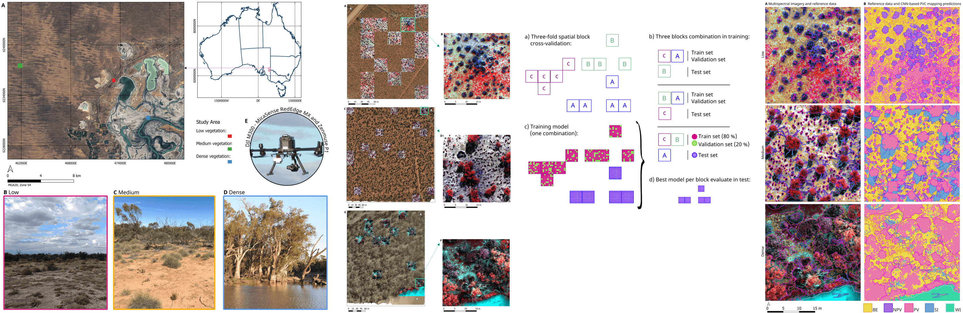
Mapping fractional vegetation cover in UAS RGB and multispectral imagery in semi-arid Australian ecosystems using CNN-based semantic segmentation
Landscape Ecology
2025-08-09 | Journal article
CONTRIBUTORS: Laura N. Sotomayor
; Arko Lucieer
; Darren Turner
; Megan Lewis
; Teja Kattenborn
Monitoring fractional vegetation cover (FVC) is crucial for assessing ecosystem health and sustainably managing semi-arid rangelands. Fieldbased methods are resource-intensive, while moderate- resolution satellite imagery lacks the spatial detail needed to capture ecosystem complexity. This study leverages centimetre-scale UAS RGB and multispectral imagery with convolutional neural networks (CNN)-based U-net segmentation framework to address these challenges.
DOI: 10.1007/s10980-025-02193-y
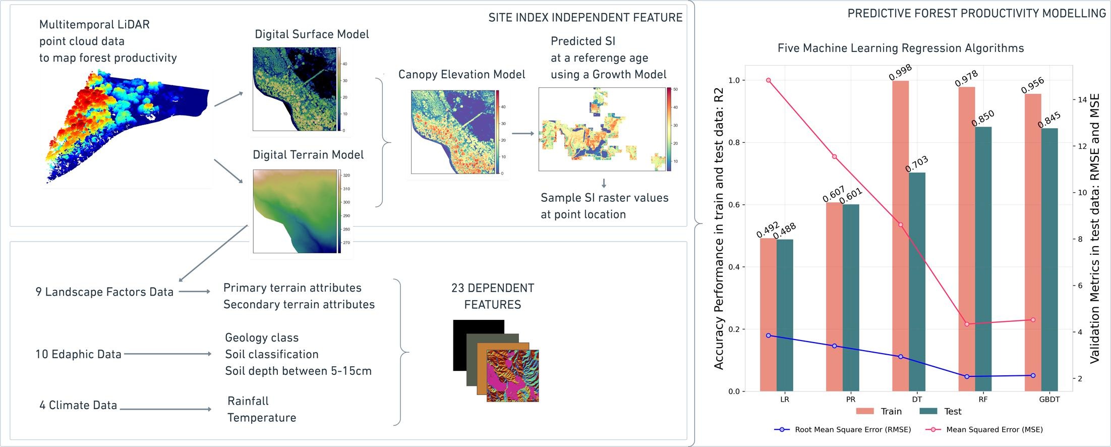
Supervised machine learning for predicting and interpreting dynamic drivers of plantation forest productivity in northern Tasmania, Australia
Computers and Electronics in Agriculture
2023-04-12 | Journal article
CONTRIBUTORS: Laura N. Sotomayor;
Matthew J. Cracknell
; Robert Musk
This project use multitemporal LiDAR to map forest productivity and employ ensemble learning algorithms to develop models that predict productivity using climatic and edaphic factors. Model interpretation and analysis by simulation identify primary productivity drivers and opportunities for silvicultural inventions (such as landscape features) to improve management.
DOI: 10.1016/j.compag.2023.107804